225km South east of Melbourne city.
 |
| Tracking route (green line) to south point, cropped from google map. |
To: South Point
20.6 km one way 單程20.6公里
41.2 km return 來回41.2公里
Here are what I brought for 2 days overnight hiking(about 8-9kg):
兩天裝備清單(約8-9公斤):
2 days' food (cookies, chocolate, chips, nuts, muesli bars).
2天的乾糧 (餅乾,巧克力,洋芋片,堅果,堅果條)
1.5L water (1.5公升的水),
1 Sleeping bag and 1 camping mat. (睡袋和軟墊)
1 Tent.(帳篷)
Canon 5D Mkll with Canon 17-40mm F4 L,70-300mm F4-5.6 L with CPL and 1 tripod.
1 Head light and 1 flash light.(頭燈和手電筒)
1 Rain jacket (雨衣)
總共到訪了這個國家公園兩次,
第一次僅有一天的時間,天氣陰, 又因為來回車程需近六個小時,所以能逛的實在有限,當天走了10km左右路程而已.
有了第一次經驗後,所以更想要安排一次兩天一夜的行程,
挑戰走到最南端.
於是觀望了天氣數週後,終於在天氣多變的春天,
等到了氣象預報兩天氣溫較暖,天氣晴朗,風勢平靜的日子.
早上四點半出發, 沿途雲層濃厚,
開到途中,便開始下起了暴雨,
加上過去數日都陸續有降雨,
所以便開始擔心起天氣和登山路況,
到了離國家公園最近的一個鎮上的麥當勞休息,
順便觀望天氣狀況.
雨停了, 所以還是決定繼續挺進.
沿路依舊有雨,但雨勢已趨緩.
快抵達國家公園內的遊客中心時,
天氣轉為明亮,太陽開始露臉,
便在海面上畫下一道彩虹,
讓我們一早便有驚喜的開始.
 |
| It's my first time taking a photo with a rainbow. 第一次與彩虹合照 |


 |
| Yes, we are ready ! See the heavy clouds ? It turned out to be rainy after a few mins walk. 我們準備好了! 看見後面的雲了嗎? 因為過幾分鐘後就開始下雨了. |
 |
| Norman Bay, long flat and wide, just about 800m from the visitor center. 諾曼灣, 寬敞且平坦,距離遊客中心約800公尺. |

 |
| 用我當比例尺就知道石頭有多大了. |
 |
| Little Oberon Bay. Pure green water and orange rock. |
 |
| Little Oberon Bay |
 |
| Little Oberon Bay |
 |
| Little Oberon Bay. Wave prints on soft and thick sand. 浪痕印在軟而厚的沙灘上. |

 |
| This is the first minor challenge, jumping across narrow stream. 這是第一次的小挑戰,跨越小溪. |


 |
| Wet rocks reflected sunlight after heavy rain. 大雨洗滌過後的大石塊,因陽光照射而閃閃發亮. |
 |
| Piles of granite rocks. 散佈成堆的花崗岩塊. |
 |
| When sun shines, sea water looks extremely clear and pure in light green. |
 |
| Such a joy taking a rest looking back the wonderful view of Little Oberon Bay. |

 |
| Oberon Bay |
 |
| Oberon Bay |
 |
| Messy rocks with vivid clouds. |
 |
| Now we have to cross the chilly and coffee-colored river. I didn't dare to taste it. |
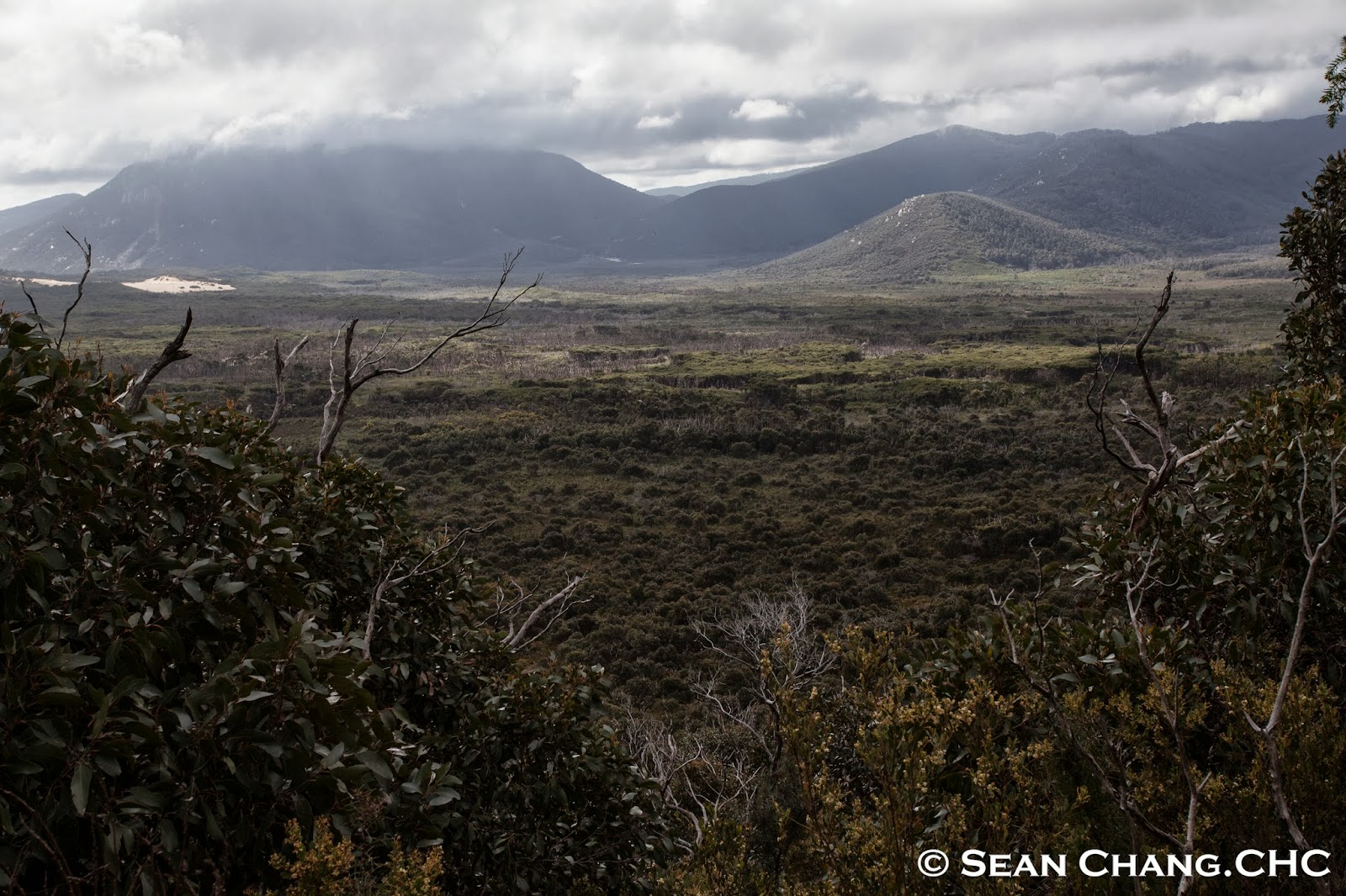 |
| In the middle of the photo shows the path we just walked along from Oberon Bay to inland, and now we're going up and cut through the forest to the south point. We are near Half way Hut, which means only 10km left to our destination. |
 |
| Almost there! Now we are back to coastline after monotonous forest view. 就快到了, 經過單調的森林景觀,我們再度回到了海岸線. |
 |
| Here we are, South Point, the southerly most point of Australia mainland. After 20.6km walk in 8.5 hrs with about 9kg backpack on my back.在背著9公斤重的背包,經過20.6公里,8.5小時後的步行後.我們到了! 南點,澳洲本島最南端. |
 |
| Sun set at the South Point. 最南端的日落. |
 |
| Pinky sky in the east after sunset. 日落後東方的天空呈現粉紅色. |
 |
| 太陽落下地平線後的美麗藍色漸層 |
 |
| Stars start to twinkle and become main actor of the sky. 星星開始閃爍並成為了天空中的主角. |

 |
| Shooting star !!! 流星!!! |

 \
\
 |
| Camping on a big flat rock under starry sky. |


 |
| Star trail of South Pole. ISO200 1323sec F4 南極點星軌. |

 |
| Around 9:20pm, moon came up above small mountains. |
 |
| Moonlight brighten rocks and Wattle Island, the milky way is still very clear to be observed. Incredible combination. 月光照亮石頭和小島, 而銀河仍清晰可見. |
 |
| Moon light. |
 |
| With moon went higher, moon light made milky way gradually more difficult to be seen. So it's time to have rest and get recharged for tomorrow's sunrise and return hiking. 隨著月亮逐漸升高, 月光會使得銀河越來越不易觀賞. 所以該是好好讓身體休息準備欣賞明天的日出和回程的步行了. |
 |


 |
| My tripod and camera almost fell from the rocks to ocean because of strong wind. When I saw the tripod shaked just a little bit, I reacted asap like a baseball player doing a diving catch to hold my tripod firmly. Otherwise, no photos would be posted. I swear I'll be far more careful when mounting camera on tripod all the time ! |
 |
| Moon was going down behind the mountain. |

 |
| We made it ! What a awesome trip to extreme point of Australia. 我們達成了, 完美的澳洲極點之旅. |
All photos are edited on Lightroom in order to convey the real scene.
所有的照片都在Lightroom上編修,以還原真實風景.
沒有留言:
張貼留言